Website Platform 8-laptop-01c

Water Rights & Land Platform

The largest integrated water and land information platform in the country

Easily search and find water rights, groundwater, streamflow, and land ownership information in an intuitive, map-based research platform. B3 Insight makes deep knowledge and data accessible to the full spectrum of water stakeholders, empowering everything from basic research to enhanced professional workflows.

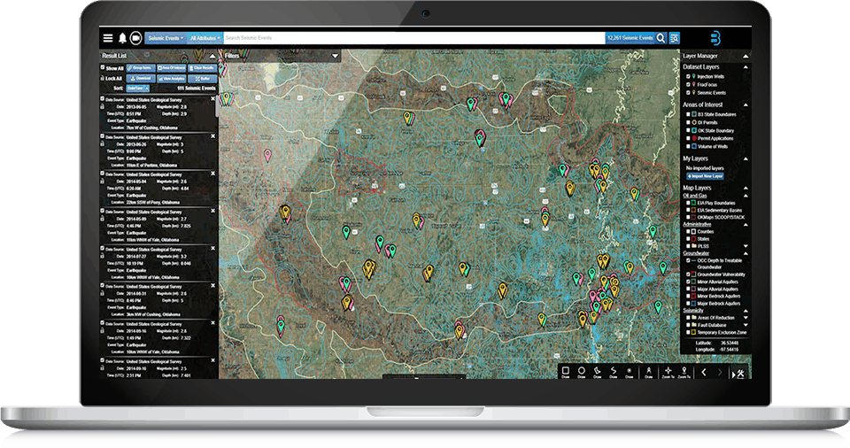
The B3 Insight Hub for Database Research

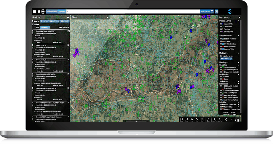
Connecting Land Ownership and Water Use

Instantly access and evaluate land parcel information in different counties through area searches, or by owner, site address, or parcel identification number. The B3 Insight Water Rights & Land Platform is the most comprehensive, integrated database for land parcels and water use, from water rights to historical water wells.

Website Platform 9-laptop-01c

Integrated Geographic And Records Databases

Cut through the noise with our water rights and land platform to easily visualize and analyze parcels and retrieve documents and records. The Water Rights & Land Platform integrates documents and records including decrees, water court resumes, well permits, diversion records, irrigation records, and more.

Platform Features

Filter & Sort

B3 filters give you tools to pinpoint specific records in large search results. It’s the power of advanced database queries, with just the click of a mouse.

Map Creator

Create, customize and export maps to share geospatial data from the B3 platform. Maps can be download as a PDF and shared with others in presentations, privately with specific individuals, or printed for reports and projects.

Export Data

You can find, evaluate and save your work in B3, but it doesn’t end there. Produce on-the-fly work product for clients. Projects, records, documents, and geographic information are all exportable in PDF, Excel, CSV, KMZ and shapefile formats.

Save & Share Projects

Create customized, self-updating dashboards and visualizations through Saved Projects. Share “Projects” across users, empowering cross-department collaboration. Improve organizational collaboration, resulting in efficient problem solving and better project outcomes.

Smart-Search

"Google-like" search functionality makes research easy, intelligent and efficient. Intuitive map element and spatial searches turn every component of your map into a powerful search tool to access diverse datasets.

Symbolization Tool

Symbolize, manage and customize visualization of datasets. Specify symbology of datasets by defining rules that control representations and labels. Enhance productivity and insight by allowing you to apply representations and label expressions to feature layers.

Import Data

Import your own shapefiles into the OilfieldH20 Platform. B3 users can upload their own geospatial data and utilize it in B3’s platform, in conjunction with B3 data for better decision making.

Reporting & Analytics

Leverage beautiful charting and reporting tools to access time series and summaries of broad data.

Empowering Smart Water Management

Scroll to Top