OilFieldH2O Platform
Analytics-ready data, mapping, and analysis
B3 Insight provides customers with the best mapping and analysis tools for water assets, development trends, business activity, and ownership information. Learn more about our datasets by downloading their fact sheets:
Transform complex data into actionable information
- Identify new market opportunities
- Generate leads and increase revenue
- Evaluate seismic event proximity and impact
- Maximize assets and increase water reuse
- Achieve operational excellence
- Optimize water logistics
- Decrease costs and reduce your oilfield footprint
- Discover disposal and mergers & acquisitions trends
- Identify water delivery, skim oil percentages, leases, and more
Thousands of data points at your fingertips
- Digitized P-18 Reports
- Historical H-10 Data
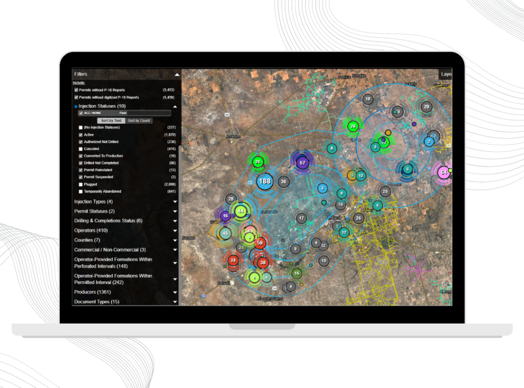
- UIC Permit Details & Application Status
- Surface Land Ownership
- Heat Maps
- Pipelines
- FracFocus (Nationwide)
- Seismicity
- Largest groundwater database in Texas and TCEQ permits
- New Mexico groundwater and surface water rights
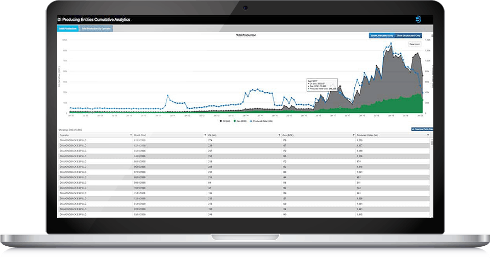
- Permits, Rigs, Wells, Completions, Production, and Leases (*DI Plus subscription)
- North Dakota produced water, including injection wells, production sites and land parcels
Verification and Enrichment Processing
- Sometimes the right information solution requires data from proprietary sources. B3’s platform is data agnostic, continually aggregating complex and diverse data from a variety of sources.
- B3’s in-house data and development teams work collaboratively to build solutions for customers that seamlessly integrate broad data into our platform.
- B3 integrates third- party, industry-specific data using a flexible and scalable architecture. Access your licensed industry datasets such as Drillinginfo, presented with B3 data in our intuitive platform.
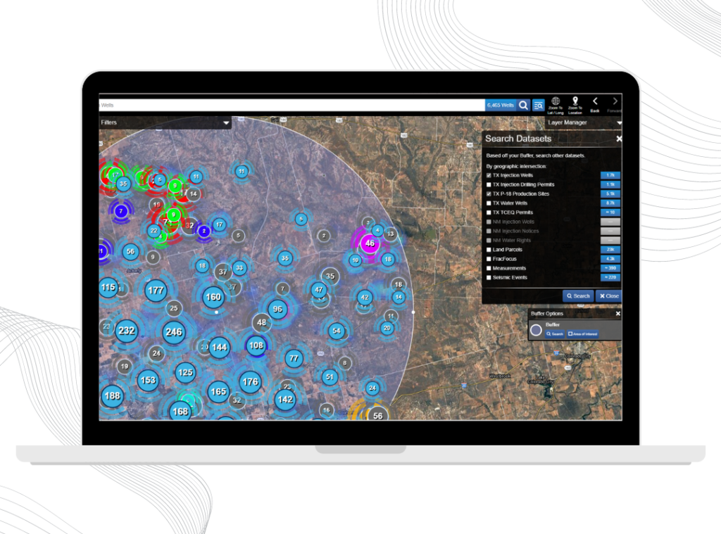
Rapid visual analysis & instant discovery
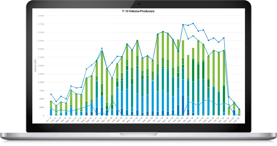
Our Production Disposal Spatial Association (PDSA) and P-18 Production Site tools enable sophisticated produced water analysis. Rapidly analyze production, movement, origination and destination between production and disposal wells.
- Visualize the point of origination of produced water
- View the straight-line distance between production and disposal wells
- Identify the producing and disposal entities and the water volume transported
- Make more informed decisions about close-proximity disposal options
- Understand water production and movement between producing and disposal entities
Your Solution for smart water management.
Solve challenges with seamless access to water data that matters to your business.
Fast track opportunities, solve challenges, and unlock new business potential better than ever with the OilfieldH2O platform.
The OilfieldH2O platform eliminates barriers between users and raw data for all experience levels. Our platform solution is built around actual business applications and guided by core data discoverability, transparency, and efficiency principles. B3 Insight’s comprehensive platform includes automated data from hundreds of data sources deployed in real-time. Users are up and running instantly with fast, accurate data insights. B3 Insight’s data and technical insights enable customers to be more internally collaborative and efficient while fully understanding the competitive landscape.
The largest and most widely used collection of comprehensive, accurate produced water data
Avoid time-consuming, frustrating, expensive, and unreliable methods with B3 Insight’s OilfieldH2O Platform. The OilfieldH2O Platform enables you to instantly visualize, search, and analyze hundreds of Bakken, Permian Basin, Mid-Continent, Rockies and Louisiana water and disposal assets, induced seismic activity, and more.
B3 Insight provides customers with the best mapping and analysis tools for water assets, development trends, business activity and ownership information.
- The Wyoming dataset is the first-of-its-kind and includes all water rights, injection wells, production sites and land parcels
- The North Dakota produced water dataset includes data from over 2,400 injection wells, 800,000 land parcels, and 26,000 production sites
- The Texas and New Mexico dataset includes water wells, disposal wells, surface owner parcels, water quality reports, water volumes, frac water use, and more
- The Oklahoma dataset includes injection wells, disposal wells, seismic events, land parcels, and more
- The Louisiana dataset includes fresh and produced water data, injection and land data, and layers for reserve pits, offshore blocks and wildlife management areas.
All available in the OilfieldH2O Platform.