By Kylie Wright
This is the first of a multi-part series from B3 on the relationship between seismicity and the water management business. Here we discuss the current understanding of the mechanics behind induced seismicity related to fluid injection and the current state of seismic activity in the Permian Basin.
Fundamentals of Induced Seismicity
It’s easy to forget that the ground we walk on is not static but a dynamic, moving thing – tectonic plates shift, volcanoes erupt, and earthquakes shudder underneath. It’s even easier to forget that we can have an impact on whether and how the ground moves below us. The mining, construction, and energy industries have the ability to impact the sub-surface through industrial activities like hydroelectric dam construction, hydrocarbon extraction and storage, minerals extraction, hydraulic fracturing, geothermal energy development, and carbon sequestration. In addition to these, there is growing concern about seismicity and sub-surface injection of fluids for disposal, particularly in the oil and gas basins of the southwestern US.
Research is ongoing and currently inconclusive regarding the triggers for induced seismicity in the Permian Basin of the southwestern US. When there was a similar increase in seismic events in Oklahoma around 2009, the finger was mostly pointed toward fluid disposal. However, the geology in the Permian Basin is very different from Oklahoma. Formations used for injection in Oklahoma have different deformational histories and are closer to brittle, crystalline basement rock than Permian injection formations. These differences may make Oklahoma’s geology more susceptible to injection-related seismicity. The increase in seismicity in the Permian Basin may be influenced by hydraulic fracturing, fluid disposal, hydrocarbon extraction, or some combination of these and other variables.
Current understanding illustrates two primary ways in which injected fluids may induce seismicity:
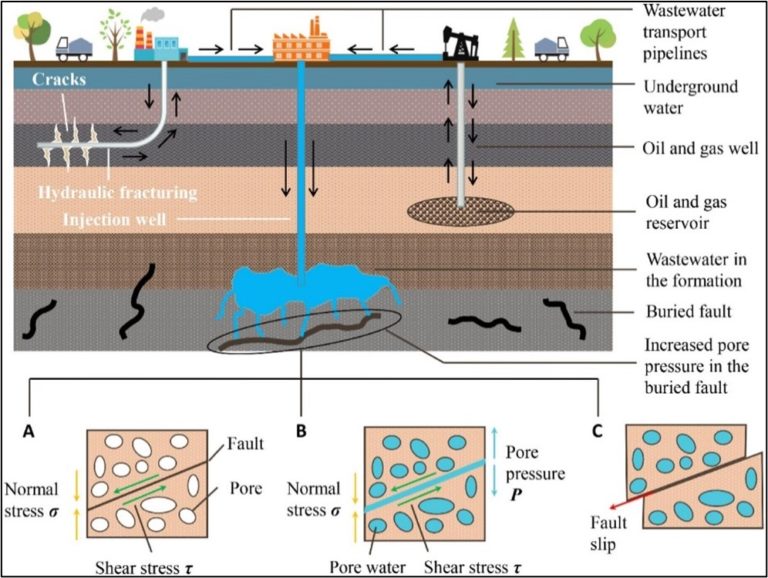
1. Fluids fill the pore spaces in faulted rocks, gradually increasing the pore pressure around faults until the force keeping a fault stationary is surpassed by the pressure of the fluid forcing the fault apart which allows the rocks to slide past one another, resulting in a seismic event (Figure 1[1]).
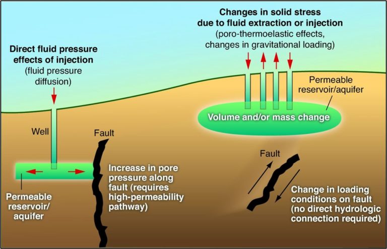
2. Fluids injected in rock formations above deeper faults can increase the pressure pushing down on those deep faults, which changes the previously stable pressure around the fault and allows the fault to slip, producing a seismic event (Figure 2 [2]).
The specific mechanics of disposal induced seismicity are a matter of ongoing scientific research, but the anecdotal evidence is mounting, and many experts are beginning to concur that sub-surface injection of fluids does have some impact on ground stability [3]. This is concerning, considering that over the past 15 years, the volume of water to manage in the Permian Basin of Texas (TX) and New Mexico (NM) has grown dramatically, from about 5.5 billion barrels of water in 2017 to over 8 billion barrels in 2020. Most of this water has been managed through sub-surface disposal, and in that same time we have seen an increase in seismicity across the Permian Basin.
Seismicity in the Permian Basin
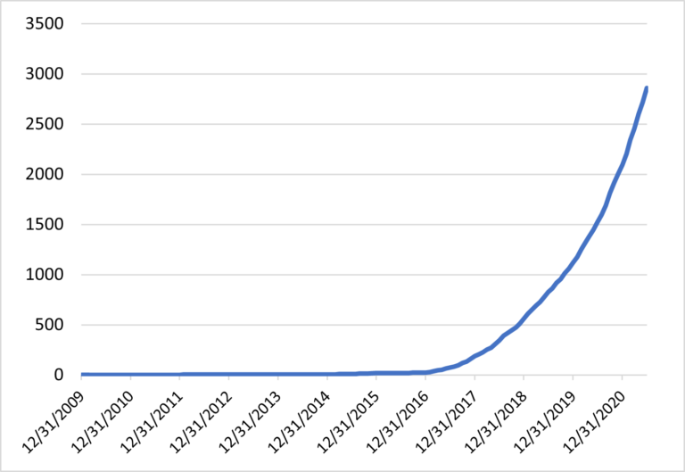
The US Geological Survey (USGS) has stated that seismic events over M 2.0 count as events of concern as they can potentially be felt by humans, though damage from seismicity does not typically occur below M 5.0 events [4]. According to state and federal records, there have been almost 3,000 seismic events over M 2.0 in the Permian Basin between January 2010 and July 2020 (Figure 3 [5]). That’s a lot of earthquakes, but even more remarkably, just under one third of them have occurred in the past year alone – since the beginning of 2021, there have been 871 seismic events over M 2.0.
Since the start of 2019, the rate of incidence of earthquakes in the Permian has increased 6%, on average, every month. If this rate of increase continues unabated, we could be facing well over 8,000 seismic events over M 2.0 by the end of 2022. In addition to the increase in frequency of earthquakes, the magnitude of earthquakes in the Permian has been increasing. According to state regulatory bodies, seismic events over M 3.5 can reliably be felt by most people on the surface, as such they are used as a threshold in seismic severity. Since the beginning of 2021, there have been more than 20 earthquakes over M 3.5 in the Permian Basin – about 46% of all recorded seismic events over M 3.5 in the Permian have occurred in the past year.
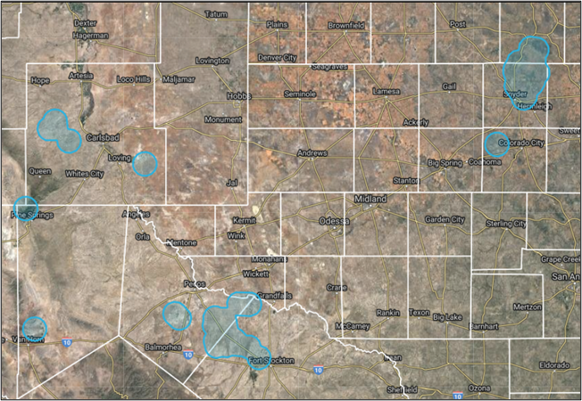
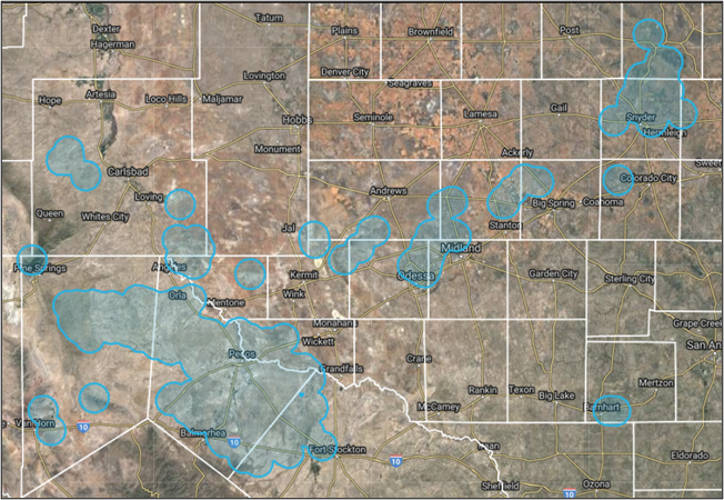
Historically, seismicity in the Permian has mainly affected the Delaware Basin, but within the past year there has been an increase in seismic events impacting the Midland Basin as well. The largest quakes in the recent recorded seismic history of the Midland Basin occurred within the past few years [5]. Just in September 2021, a M 3.7 earthquake and a M 2.6 earthquake struck on the Martin-Midland County border, driving recent requests for injection rate reductions in the region [6]. Currently, about 7,500 square miles of the Permian falls within a 5.64 mi radius [7] of a quake M 2.0 or greater; by the end of 2022 this could reach almost 11,000 square miles (7.0 million acres) (Figures 4a and 4b).
Implications of Increasing Seismicity
Seismicity has been the primary driver of new regulation impacting oil and gas operations in the Permian Basin over the past few years. Public awareness of seismicity in the southwestern US is at an all-time high while public tolerance of seismicity is at an historic low. This is understandable; seismicity is concerning and uncertainty around the causes of seismicity heightens those concerns. To address some of these worries, regulatory bodies have been racing to develop rules and guidelines for the energy industry with the goal of reining in the growing number and size of earthquakes across the southwestern US. Much of this new regulation is focused on limiting the pressure, rate, and total volume of fluid injected into the sub-surface with the assumption that less fluid injection will mitigate seismic risk. New regulations have serious cost implications for producers’ disposal permitting and operations, adding additional time demands, equipment, and expenses, which will be further exacerbated as disposal volumes continue to soar.
B3 is working with industry experts to develop data driven solutions around seismicity impacts to water management. Visualizing the nexus of water management operations, oil and gas development, and seismicity, as can be done in B3’s OilfieldH20 Platform, will be imperative in planning future drilling schedules and guiding investment in infrastructure in an uncertain regulatory environment. In the next installment of this series, we will review the evolving nature of water management related seismic regulations in detail and the associated economic implications.
[1] He, M., Li, Q., Li, X. Frontiers in Earth Science. Injection -Induced Seismic Risk Management Using Machine Learning Methodology – A Perspective Study. https://www.frontiersin.org/articles/10.3389/feart.2020.00227/full.
[2] Ellsworth, W.L. Science. Injection-Induced Earthquakes. https://www.science.org/doi/10.1126/science.1225942.
[3] Grigoratos, I., Rathje, E., Bazzurro, P., Savvaidis, A. Bureau of Economic Geology. Earthquakes Induced by Wastewater Injection, Part I: Model Development and Hindcasting. https://www.beg.utexas.edu/node/6265.
[4] https://www.usgs.gov/faqs/what-magnitude-does-damage-begin-occur-earthquake?qt-news_science_products=0#qt-news_science_products/.
[5] Bureau of Economic Geology TexNet Earthquake Catalog. https://www.beg.utexas.edu/texnet-cisr/texnet/earthquake-catalog.
[6] M 3.7 – 16 km NNW of Midland, Texas. https://earthquake.usgs.gov/earthquakes/eventpage/tx2021rnek/executive.
[7] 5.64 mi radius corresponds to a circular area of 100 square miles centered around the seismic event.
[8] B3 Insight OilfieldH20 Platform. https://www.b3insight.com/oilfield-platform/.